Nevada Division of Water Resources, USGS and Desert Research Institute hydrologists presented an annual update on groundwater studies in the Humboldt River Basin last week. Lovelock city hall was filled with farmers, ranchers, water rights engineers and attorneys.
The four-year water modeling is intended to better understand the conflicts and connections between ground and surface water in the Upper, Middle and Lower Humboldt River Basin. The USGS and DRI studies should be done by late 2019 or early 2020, water officials told the crowd.
DWR hydrogeologist Jon Benedict said more hydrology data means better water management.
“Why are we doing these modeling studies?” he said. “We’ve got a problem with surface water. Surface water rights are senior to groundwater rights. Downstream surface water rights holders didn’t get their water from 2013 to 2015. Existing studies show groundwater pumping can impact surface water. The problem is we don’t know the extent of that depletion.”
Benedict said a detailed model will better illustrate the impacts of wells on the Humboldt River.
“The models will be able to simulate complex natural systems and regional pumping,” he said. “A model is the best and only way we have to quantify the problem; the amount and locations where pumping captures river flow. We hope it will be used as a tool to manage the problem.”
In 2016, meters were ordered for all groundwater wells, except domestic and stock water wells, in the HRB. Monthly readings have been supplied to the state from 95 percent of the 1,181 wells. Water officials said the high compliance rate will improve groundwater management.
“With this order we’re much better able to monitor the resource we’re trying to manage in terms of groundwater,” Benedict said. “The vast majority of pumping occurs below Palisade in the middle and lower Humboldt River Basin.”
Interactions between the aquifer, irrigation ditches and canals are being studied for a model of the Lower Humboldt River Basin using groundwater monitoring wells in the Lovelock Valley.
UNEQUAL WATER RIGHTS
Decreed, priority, senior surface water rights in the Lovelock Valley date back to the 1860’s and most of the junior groundwater rights upstream were developed after the 1950’s, said Benedict.
“The amount of decreed water rights is about the same as the groundwater appropriations in the Humboldt River Basin,” he told the crowd. “It’s about 700,000 acre-feet for both.”
The 716,000 acre-feet of appropriated groundwater is “quite a bit larger” than the perennial yield, meaning a number of the 34 groundwater sub-basins are over-appropriated, Benedict said. However, the actual pumping in 2016 was 325,000 acre-feet, that is less than perennial yield.
Mines hold “temporary” water rights and have fully cooperated with the studies by providing all requested data on groundwater pumping, storage and use, according to the scientists.
UNIFIED RESOURCE
The scientists said streams and rivers tend to rise and fall along with groundwater levels.
Groundwater pumping, however, disrupts the equilibrium by lowering nearby water tables over time and eventually causing long-term depletion of springs, streams, rivers and vegetation. The scientists said studies will help water officials anticipate groundwater pumping impacts.
There will be more public hearings in 2018 on the legislative issues behind water management. Conjunctive management, for example, could mean financial compensation for water rights.
“The state engineer is working with the legislative counsel bureau on aspects of potential regulations and he’s planning to have public meetings in the first half of 2018,” said DWR hydrologist Adam Sullivan. “Those meetings will be broadly advertised.”
A GOOD WATER YEAR
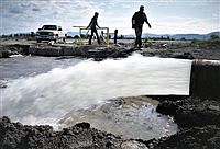
The Humboldt River’s total annual flow for the 2017 water year at the Palisade gauge was over 800,000 acre-feet of water and about 650,000 acre-feet at the Imlay gauge, Sullivan said.
“This was comparable to 2006 and was exceeded only by 1983, 1984,” he said. “The effect on the long-term average at those gauges was to raise the average flow by seven or eight thousand acre-feet with the Palisade average about 300,000 and Imlay about 200,00 acre-feet.”
This year’s water picture is “starting off much drier” with 73 percent of normal precipitation in the Lower HRB and 71 percent in the Upper HRB. A warm winter, with more rain than snow so far, has produced 31 percent of the normal snow-water equivalent in the Lower HRB.
But, Sullivan said it’s too early to classify the water year. The NRCS forecast on Jan. 1 predicted river flows of about 146,000 acre-feet at Palisade and 63,000 acre-feet at Imlay.
On Jan. 1, Rye Patch Reservoir held 157,000 acre-feet of water or 81 percent of maximum storage after a more than full irrigation season, up to four acre-feet, for Lovelock Valley farmers.
Lovelock Valley farmer Tom Moura questioned the need to study the basin. In his opinion, state officials already have the data and are “just buying time” before making difficult water decisions.
“They have all the information they need. This is just slowing the process,” he said. “They have to fall back on senior rights and junior rights. Prior appropriation; I think that’s plain and simple.”